When I started writing this blog-post on Oregon, I came across the website Travel Oregon.It mentions the Seven must sees of Oregon, which are Mt. Hood, The Columbia River Gorge, The Oregon Coast, Crater Lake, The Painted Hills, Smith Rock and The Wallowas. To our delight we had already done some of them. Below is a glimpse of our trip.
After spending a few hours at Crater Lake National Park, we headed towards Portland. Below is a glimpse of our trip route map.
After spending a few hours at Crater Lake National Park, we headed towards Portland. Below is a glimpse of our trip route map.
View Portland Roadtrip in a larger map
1.) THE GROTTO:

It is a popular name for the National Sanctuary of our Sorrowful Mother. The heart of the Shrine is Our Lady's Grotto, a rock cave carved into the base of a 110 ft cliff with a life size marble replica of Michelangelo's Pieta featured in its centre. It's a place that welcomes all religions. Whilst we were there, there was a large Asian melodious choir that performed and they were fantastic.
The Grotto is a peaceful place to reflect, pray or just enjoy the garden.
The Grotto also has an Upper Level Garden that you can visit. If you are going...
Location: 8840 NE Skidmore St, Portland, OR.
Website: http://www.thegrotto.org/
2.) COLUMBIA RIVER GORGE HIGHWAY AND SCENIC SPOTS:
The best way to experience it is to drive on it. This is definitely a recommended must do. The views from various scenic view points are simply break taking. Below is a picture of the road as soon as we had entered the highway.
 |
| Columbia river gorge scenic highway |
The picture of the Crowne Point Vista House from this location with the vastness of the Columbia River gorge is one of the reasons for our visit to Oregon. It is one of the most frequently photographed pictures. Sunset from here is beautiful.
4.) CROWNE POINT VISTA HOUSE:
A little history of the house taken from this website. Please check the link for latest weather and other updates.
5.) MULTNOMAH FALLS:
 |
| Crowne Point from womens forum vista point |
4.) CROWNE POINT VISTA HOUSE:
A little history of the house taken from this website. Please check the link for latest weather and other updates.
 |
| Crowne Point Vista House |
I have always wanted to visit Multnomah after seeing a write up on it on one of the travel magazines. This is one of my favorites without a doubt. We were lucky that day as we got a chance to experience a group of Native Americans in their traditional colorful outfits performing traditional dances in front of the falls.
 |
| The dance troupe at Multnomah Falls |
 |
| Dancers at Multnomah Falls |
After the show, we headed to go to the bridge over the falls. Take a snails pace walk and go uphill to Benson Bridge. You can hike further for about 14 miles ( to and fro ) and complete the Multnomah Falls Hike! For more details on this hike and the Larch Mountain Hike check this link.
 |
| Multnomah falls |
 |
| entrance to multnomah falls |
 |
| Multnomah Falls |
We had planned to visit about 3-4 falls near Multnomah but due to lack of time we planned to skip it. Here is a website that gives you a list of all the waterfalls in the vicinity along with their distances and accessibility.
6.) BRIDALVEIL FALLS:
We stopped by the Bridal veil falls state park: our intention to do a short hike. We decided to take the Upper trail (vista point trail). Now I wish we had done the falls trail. This led us to the precipice of the cliffs of the gorge. There were pretty purple wildflowers on the trail. The viewpoint from the end of the trail was this gigantic river paving its way around the mini islands of the Columbia River Gorge. In the below picture, the left side of the island is Oregon and the area on the right is Washington. For details on the hike to Bridalveil Falls click here.
 |
| View from Bridal View state park looking north west. |
7.) BONNEVILLE LOCK AND DAM:
The Bonneville Dam is worth viewing if you are in the area as it is a National Historic Landmark. The project’s first powerhouse, spillway and original navigation lock were completed in 1938 to improve navigation on Columbia River and provide hydro power to the Pacific Northwest. To read more about the dam facts visit this website. Visitors can watch the navigation lock in operation when commercial or recreational boats are traveling up or downstream.
Included within the Lock are Adult Fishways:
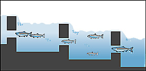
The best months to see the fish climbing the fish ladders are as follows:
Chinook Salmon ......... September
Chinook Salmon ......... September
8.) BONNEVILLE FISH HATCHERY:
Viewing area to watch fall spawning activities.
9.) HOOD RIVER WATERFRONT PARK:
This could be the entry point to the Mount Hood Scenic Byway. Have a lunch or picnic here. This is a good place to unwind, have a picnic or just relax.

10.) MOUNT HOOD SCENIC BYWAY:
One of the many things learnt on taking road trips is to go with your gut feeling.What may be a good drive for someone may not be yours and vice versa. Whilst making the itinerary, we read about Mt. Hood Scenic Byway but missed out on the duration of the drive. That was one of the biggest errors made in terms of our planning. The drive to the base of Mt. Hood was so different from the pictures above that we saw on the Columbia River gorge highway. We passed by vineyards, farms and were almost at the base of Mt Hood. We drove the entire byway for around 5 hours.
 |
| Mt. Hood |
We drove this way sometime in July. We were probably the only car going in the south direction and was very lonely. We did enjoy the drive but in hindsight if we were well prepared we would have probably preferred to do about an hour or two on this highway upto the base of Mount Hood.
11.) CANON BEACH:
We missed out on driving to the Canon Beach due to lack of time largely because of the long drive along the Mount Hood Scenic Byway. So this maybe for another trip. However we want to mention it here as the pictures we have seen are just breath taking. For more details on Cannon Beach click here. The closest to seeing the Canon Beach landscape is probably Morro Rock in California.
On the whole, Portland is worth visiting, The Columbia Gorge is surely a 10 star rating with Multnomah Falls. The drives were scenic in July, I can just imagine what it would be like in fall!


